
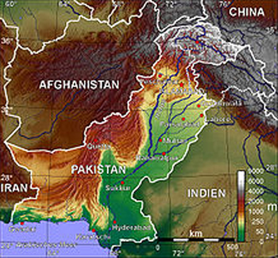
| Location: | Southern Asia, bordering the Arabian Sea, between India on the east and Iran and Afghanistan on the west and China in the north |
| Geographic coordinates: | 30 00 N, 70 00 E |
| Area: | total: 803,940 sq km land: 778,720 sq km water: 25,220 sq km |
| Area – comparative: | slightly less than twice the size of California |
| Land boundaries: | total: 6,774 km border countries: Afghanistan 2,430 km, China 523 km, India 2,912 km, Iran 909 km |
| Coastline: | 1,046 km |
| Maritime claims: | contiguous zone: 24 NM territorial sea: 12 NM continental shelf: 200 NM or to the edge of the continental margin exclusive economic zone: 200 NM |
| Climate: | mostly hot, dry desert; temperate in northwest; arctic in north |
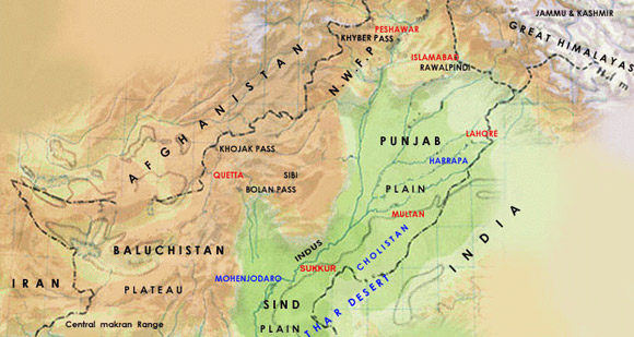
| Terrain: | flat Indus plain in east; mountains in north and northwest; Balochistan plateau in west |
| Elevation extremes: | lowest point: Indian Ocean 0 m highest point: K2 (Mt. Godwin-Austen) 8,611 m |
| Natural resources: | land, extensive natural gas reserves, limited petroleum, poor quality coal, iron ore, copper, salt, limestone |
| Land use: | arable land: 27.81% permanent crops: 0.79% other: 71.4% (1998 est.) |
| Irrigated land: | 180,000 sq km (1998 est.) |
| Natural hazards: | frequent earthquakes, occasionally severe especially in north and west; flooding along the Indus after heavy rains (July and August) |
| Environment – current issues: | water pollution from raw sewage, industrial wastes, and agricultural runoff; limited natural fresh water resources; a majority of the population does not have access to potable water; deforestation; soil erosion; desertification |
| Environment – international agreements: | party to: Biodiversity, Climate Change, Desertification, Endangered Species, Environmental Modification, Hazardous Wastes, Law of the Sea, Marine Dumping, Ozone Layer Protection, Ship Pollution, Wetlands signed, but not ratified: Marine Life Conservation, Nuclear Test Ban |
| Geography – note: | controls Khyber Pass and Bolan Pass, traditional invasion routes between Central Asia and the Indian Subcontinent |