
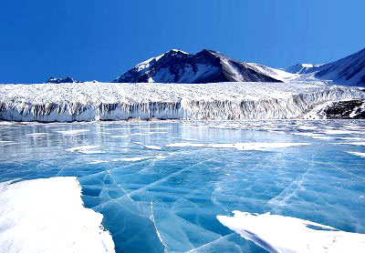
The Biafo Glacier is a 63 km (39 mi) long glacier in the Karakoram Mountains of the Northern Areas, Pakistan which meets the 49 km (30 mi) long Hispar Glacier at an altitude of 5,128 m (16,824 ft) at Hispar La (Pass) to create the world’s longest glacial system outside the polar regions. This highway of ice connects two ancient mountain kingdoms, Nagar (immediately south of Hunza) in the west with Baltistan in the east. The traverse uses 51 of the Biafo Glacier’s 63 km and all of the Hispar Glacier to form a 100 km (62 mi) glacial route.
[nggallery id=27]
The Biafo Glacier presents a trekker[1] with several days of very strenuous, often hectic boulder hopping, with spectacular views throughout and Snow Lake near the high point. Snow Lake, consisting of parts of the upper Biafo Glacier and its tributary glacier Sim Gang, is one of the world’s largest basins of snow or ice in the world outside of the polar regions, up to 1,600 m (0.99 mi) in depth.
The Biafo Glacier is the world’s third longest glacier outside of the polar regions, second only to the 70 km (43 mi) Siachen Glacier disputed between Pakistan and India and Tajikistan’s 77 km (48 mi) long Fedchenko Glacier.
Campsites along the Biafo are located off of the glacier, adjacent to the lateral moraines and steep mountainsides. The first three (heading up fr amla has an amazing waterfall very near the camping area. Baintha, the third camp site, is often used as a rest day. A large green meadow, it has a few running streams near the camp and many places to spend the day rock climbing or rappelling.
Evidence of wildlife can be seen throughout the trek. The Ibex and the Markhor [[gs are rare.
How to reach?
Flights between Islamabad and Gilgit
Gilgit has an airport, providing daily flights to Islamabad, punctuated only by adverse weather conditions. Pakistan International Airlines (PIA) flies 12 weekly flights between Gilgit and Islamabad and the flight is one of the most scenic flights of the world as its route passes over Nanga Parbat and the mountain’s peak is higher than the aircraft’s cruising altitude. These flights, however, are subject to the clearance of weather and in winters, flights are often delayed by several days
- Airport Type – Public
- Elevation – 4,781 ft (1,457 m)
- Length – 5,400 ft (Asphalt) 983 ft (Concrete)
- Phone Number – 92-572
- Coordinates – 35?55’07″N, 4?20’01″E
- Time Zone:+5:00 hours from UTC/GMT
- Airport Code:
FlightStats code: GIL
IATA code: GIL
ICAO code: OPGT
Flights from Islamabad to Skardu:
Skardu KLatitude / Longitude:
35.3 / 75.73333Time Zone:
+5:00 hours from UTC/GMT
FlightStats code: KDU
IATA code: KDU
ICAO code: OPSD
Skardu Airport (IATA: KDU, ICAO: OPSD) is a small domestic airport, located at Skardu, Northern Areas, Pakistan. Skardu is one of the two major hubs of all trekking expeditions in the Northern Areas, a region that includes four of the fourteen Eight-thousander peaks (8,000 m (26,247 ft) and above) of the world. Skardu is the gateway to Baltoro Glacier, Concordia, where spectacular views of three of the Eight-thousanders are available.It is also being used as a regional PAF airbase.
Although the journey from Islamabad to Skardu by Karakoram Highway provides a beautiful scenery, the journey by road takes 20 to 24 hours whereas the flight time for the same journey is nearly an hour. This makes air travel from Islamabad to Skardu an attractive choice for many trekkers.

Book online flights here: